In my last post we saw how plotting round lon,lat coordinates on a flat X,Y map results in the map scale getting stretched in the east-west direction (while staying constant in the north-south direction) the farther we go away from the equator. This makes it quite difficult to plot a course for navigation since the angles between lines will vary also.

Gerardus Mercator, born March 5, 1512, realized that he could maintain the angles (direction) by stretching the map in the north-south direction the same amount as it was being stretched in the east-west direction. The scale is proportional to the secant of the latitude, but since there were no computers back then, and a table of secants had not yet been developed, Mercator likely determined the spacing graphically.
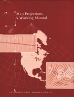
John Snyder’s classic USGS Professional Paper 1395 describes the mathematics behind map projections and includes a section (pages 38-47) on the Mercator Projection. Here’s a link to the USGS website which includes a link to a digital version :
So problem solved - by stretching the map north-south and east-west by the same amount, sailing routes between two points will be shown as a straight line.

But what about Greenland and South America? While the Mercator Projection has benefits for use in navigation, all the stretching that is done to preserve direction has a down side – area becomes greatly exaggerated. We saw this in my previous post.
A hui ho!
No comments:
Post a Comment